Monday, February 28, 2011

To Franklin lock
2-26 thru 2-27-2011

We left Burnt Store Marina at 9:30 the next morning and we were back in the Gulf ICW by 11:00 am. We had some chop in Charlotte Harbor with waves 1-2 feet, but by the time we were in the ICW it was milder. We are headed for Ding Darling anchorage, at Sanibel Island. We arrived there about 2:00 pm. There were several motor vessels and sailboats already anchored. “The Old Grouch” came in after us.
 As we were finishing our dinner we saw a small boat coming through the anchorage. He pulled up to several boats so we thought he might be a park ranger or something. When he got to our boat he told us he was looking for terrorist and asked if we had seen any. We told him the boat behind us (“The Old Grouch”) was from Canada and we weren’t sure about them. Those of you that know Shay know that he has never met a stranger, so of course they started talking. Ieli finally tied up to our boat, got out his Hungarian plum brandy, and offered us a sip. We tried it and it was pretty good. I went below and cleaned up dishes and Shay and Ieli talked for a couple of hours. He told us he had a cattle farm in Arkansas and a potato farm in Maine. He tried to get us to stay another day and come visit him. We explained we had to leave. He gave us his name, phone number and address and told us to let him know when we came back thru. When it started getting dark he decided he’d better head home. Since it was getting cool, he took another drink of brandy to keep him warm, and headed home. He was a very interesting character with a heavy Hungarian accent. We decided he’s like the older men in our hometown that go to the mall or a fast food place everyday to meet friends and “shoot the bull”. Instead of jumping in his car, he got in his dinghy and went to the local anchorage. Wonder if he every sees any “terrorist” and what he would do with them if he did?


            Sunset at Ding Darling anchorage.  Wonder how it got its name?

     We left the next morning heading to our next destination. We had problems with our autopilot. The fluxgate compass was off 180 degrees and caused the chart plotter to display the boat running backwards. Every time we tried to activate it, it wanted to turn the boat around 180 degrees. So we had to steer the boat by hand until we could get it figured out. That doesn’t sound that bad, but it was very confusing with the boat symbol going backwards on the chart plotter but in the correct position on the chart. We called several people, on both the VHF radio and phone trying to find someone to help us. So “the Admiral” as Shay calls me, got out the manual on the autopilot and found instructions on how to align the autopilot’s fluxgate compass with the GPS heading. Following the instructions we were able to align the fluxgate compass with the GPS heading and this turned the boat symbol around and pointed it the correct direction on the chart plotter. Like magic, we were able to use the auto pilot again, which makes driving the boat much easier. We had gone through the “miserable mile” at Fort Myers without using the autopilot. We didn’t really understand why it was called “miserable mile”, but it was sure miserable for us.
 We passed by all the tall buildings and marinas at Fort Myers on to our first lock, the WP Franklin Lock. Let me explain what going through a lock involves. You go into the lock, get close to the concrete sides, grab lines on the bow and stern, hold on while the gates are closed and water is let either into or out of the lock. When the water level equals the water level on the other side of the lock the gates open, you drop your lines and take off. It may sound simple, but bringing a 49 foot boat up against a concrete wall in the wind and waves in not simple. We were lucky, the wind was calm and Shay brought the bow close to the line, I grabbed it then he ran back to the stern. This lock only changed about 2 feet. We were surprised by the swift current as the water level quickly changed.
 When I looked for pictures I was surprised we didn’t have any. Thinking back, I guess we were to busy when we were going in and coming out to stop and take a picture. Sometimes on a boat you miss those “Kodak moments” ‘cause you don’t have time to stop.


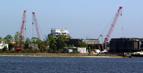
A picture of the Franklin Lock with the RV park and small marina on the right end of the island.

Just past the lock is a small marina/RV campground ran by the Army Corps of Engineers. We decided to spend the night here since the cost was only $24.00 per night. We got checked in and met some our neighbors. Did I mention that Shay has never met a stranger? One couple told us about a creek we could explore by dinghy. We had only planned to spend the night but Shay was still tired from the crossing and we decided we’d stay 2 nights instead of one.
 This is a beautiful place. Across from our dock, the anchorage is covered in water lilies. We saw what looked like thousands of birds nesting in a tree nearby. When we checked in we ask if there were any alligators in these waters. The attendant told us one usually sunned on either side of the lock. He looked around but didn’t see either one. He said if I really wanted a picture to push Shay in and start taking pictures, it wouldn’t be long before the gator would be chasing him across the water. I decided that wouldn’t be a good idea, since it takes at least 2 people to handle “Escape”. I have already told Shay that he has job security as my husband as long as we have the boat, since I need him to drive. Later that evening, just at dusk we saw a pair of eyes and a nose swimming across the waterway. It didn’t take a genius to figure out that it was a gator. We had noticed a swimming area on the other side of the lock. I don’t think I want to get in this water, since the gator can go from one side of the lock to the other without waiting for the lock master to let him pass.
The next morning we got the dinghy down off the boat. For those of you that don’t know what a dinghy or dink is, ours is a 10 foot 2 inch long fiberglass hull with an inflatable tube around it. Ours has a 15 horsepower Honda outboard, that will make it fly. We headed east on the Caloosahatchee River to the Hinckley Creek. We went by some beautiful houses on the river and turned into the creek. We were told we could travel 4-5 miles back into the creek. We were told to go until we thought we couldn’t go any further and then keep going about 2 more miles.


We saw turtles sunning on the banks, sunning on logs, and swimming under the water.


 The banks were covered in palm trees and other lush vegetation. The trees were so thick in some places, they blocked out the sky. The water was covered with water lilies, but I was disappointed since only a few were blooming.

It looked like a scene out of an Indiana Jones movie. I expected “natives” to be standing around every turn with spears in their hands.
Every time we thought we’d come to the end, we’d go a little further and see another bend in the creek. The further we traveled the fewer houses we saw.


We finally decided to turn around and start back. We decided we would be in big trouble if we hit something and messed up the prop on the engine.

  Just before we left the creek, we saw gator eyes sink under the water --twice. Shay slowed down but I told him I didn’t want to get “up close and personal with a gator”, so we moved on. We decided if we’d seen them going in we might not have gone so far back into the creek.


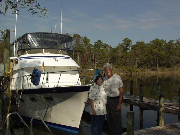
Back at the boat, we put the dingy up, visited with the De Fever next to us, and then settled in for another quiet night on the water.

We were so glad we took this side trip. I bet this will be one of the highlights of our travels.
Next we are off to La Belle.


Friday, February 25, 2011

Crossing the Gulf

This is Dog Island February 23, 2011. 
The guys left at 7:20 to start the crossing.

Looking back at East Pass. This is the last look at land for a while.


This is a map showing Dog Island.


The view off the fly bridge at the start of the trip.

The view off the fly bridge later that same day.
At 4:00 pm the fog rolled in and lasted until 2:00 am the next morning. Motoring through the fog was scary for everyone on board.


Captain George stands by while Captain Mike watches over things from the captain’s chair. After the fog moved in it got cool.


Looking out on the foggy gulf.


The guys saw dolphins during the entire trip. They were surprised to see them at night. The dolphin could be seen at night playing in the bow wave of the boat, under the navigation lights.


Captain Shay takes his turn at the helm.

Looking at the first marker into Boca Grande. This was the first marker after 257 miles.

Below is a map showing the route they took across the Gulf.


This shows the Boca Grande Inlet and Burnt Store Marina.
  

Condos at the entrance into Charlotte Harbor.


They tied up at the Burnt Store Marina at 3:30 pm February 24, 2011. The trip took 35 hours. Shay said it would have been a perfect crossing if it hadn’t been for the fog. The trip from East Bay to the entrance to Boca Grande Inlet was 257 miles, taking them as far as 67 miles off shore at one point.

George and Mike left to start their trip back to Niceville to pick up our car and start back to Mount Airy. They were tired but wanted to travel some before it got too late. We enjoyed having them on the boat and appreciated their help doing the crossing and getting our car back home. They are great friends.

We had dinner at the marina with Dave and Brenda, a Canadian couple on the boat “The Old Grouch”.


Tuesday, February 22, 2011

Getting Ready for the Big Bad Gulf Crossing

Date 2-20 thru 2-22 2011

We are on our way to East Pass to start our important and intimidating Gulf Crossing.

To get the boat from the Panhandle of Florida, back to North Carolina we need to leave the northern Panhandle and cross diagonally to the west coast of Florida. The water in the northeast corner of the Panhandle is too shallow for our boat.


We left Hogtowne Bayou crossed Choctawhatchee Bay and traveled east on the Gulf Intercoastal Waterway.


East of Choctawhatchee Bay, we entered a white sandy bank canal that we followed to West Bay. The weather was perfect. The water and winds were calm.


Next we entered St Andrews Bay, where the winds picked up to 15 kts. We passed Panama City and anchored in Pearl Bayou. Everything was well marked which made our trip easy. Again we had a hard time getting our anchor to set properly. We spent a peaceful night at Pearl Bayou. 

Below is a map showing Pearl Bayou.


The next day we continued traveling in the waterway to East Bay where we saw men harvesting clams from the shallow bottom.


This is a big boat we saw being built along the way.


We continued on the waterway across Lake Wimico to Jackson River to Apalachicola and spent the night at Scipio Marina. Docking was easy with a side tie and no problems from the wind or current.


We had lots of recommendations for the Scipio Marina but I was disappointed. Maybe I was expecting too much, the bathrooms and laundry room left something to be desired. Our friends, George and Mike met us to spend some time on the boat. We ate at Pappa Joe’s Restaurant. We had heard their oysters were great. I don’t do oysters but Shay, George, and Mike seemed to like them.

Below is a map showing Apalachicola.

We looked at all the weather information we could find and the guys decided it was time to do the crossing. They left the marina the next day, crossed Apalachicola Bay to St. George Sound and anchored at Dog Island next to East Pass where they would start their Gulf Crossing. They plan to leave early on February 23 to cross the Gulf.  Shay planned to go in at Boca Grande Inlet to Charlotte Harbor, if the weather stayed good. He had routes into several other inlets if the weather changed. Shay filed a Float Plan with me and Dave, the previous owner of our boat. The Float Plan included the description of the boat, the people aboard and their contact information, where and when the trip would start, and where and when he expected to arrive. This information would be used in case of an emergency. I would not make the crossing but would drive to meet them at Burnt Store Marina in Charlotte Harbor so Mike and George would have a car to return to Niceville. They will pick up our car and drive both back to Mount Airy, NC.

Saturday, February 19, 2011

Finally Leaving Niceville

When you move onto a new boat, everything is a new experience, even if you’ve owned a boat before. Today we will have several “firsts”. We will be leaving Shirk’s Bayou for the first time. We’ll be leaving on a trip for the first time. We will be going into a marina, tying up and getting fuel and pumping out the holding tank for the first time. We left the marina with 1100 gallons of diesel fuel. We are full. This is probably the cheapest fuel we will buy at $3.03 a gallon. We’ve decided to spend our first night on the water at Hogtowne Bayou, near Sandestin.

We have many mixed feelings. We are tired, from all the work we’ve done the past several weeks. We are nervous, about handling a boat this big. But mostly, we are excited that it is finally happening and we are heading to Morehead City, NC.


Departure day for Escape, we were tired but ready to go.


We left Shirk’s Bayou at 11:05. The weather was perfect, with clear skies, calm water, and a gentle breeze.


Dave and his neighbor were our escort out of Shirk’s Bayou. They helped us find the way over the shoal that blocks the entrance into Shirk’s Bayou.


Dolphins wishing us safe travels, as we leave the Bayou. I hope these will be the first of many we see along the way.


This is the first of many barges that we will meet in our travels. It sure did make us feel small.
Our first of what will be many bridges, big and small.


Well, we made it through our first day. Shay handled the boat like he knew what he was doing. We had no problems at the marina, although we did tell the dock master this was our first time and we’d take all the help we could get.


Our first night at anchor was spent at Hogtowne Bayou. We were anchored with one other boat near Sandestin, Florida. We had some trouble getting the anchor to set and hold properly. This was a great place to anchor. The wind was dead calm, after dark the water looked like glass, and the sky was full of big bright stars. Shay said he bet this would be the quietest night we would ever have on the water. I hope it is the first of many.

Below is a map showing Hogtowne Bayou.


One thing we have noticed about fellow boaters is that most of them are ready to help if it’s catching a line, answering a question, or giving advice. We have already met many helpful boaters. Some have visited Escape and given us advice from anchor selection to how to use it properly. Others have given us advice about charts, charting software, and even showed us how to change the fuel filters on the engines. We look forward to meeting many more helpful boaters as our travels continue.

Oh, I almost forgot. Our boat broker, Lenny Beck, called today and reminded us to include in our blog just how lucky we were to have such a great boat broker guiding us through the process of buying Escape.

Friday, February 18, 2011

New Boat

M/Y ESCAPE

  We bought our 2002 DeFever 49' Cockpit Motor Yacht November 1, 2010. The previous owners, Dave and Sandy, were nice enough to let us keep the boat in their slip behind their house, until we both retired. We moved onto the boat on January 18, 2011 and started preparing Escape for her long trip to her new homeport at the Morehead City Yacht Basin, in Morehead City, North Carolina.


This is a map showing Niceville, Fl.


We did a variety of work on the boat, including repairing the Raymarine electronics, changing the raw water cooling pump impellers, checking heat exchangers, and general cleaning and moving stuff aboard, including a lot of tools and a new toolbox. When we thought we had the boat almost ready to go, the refrigerator quit. It wasn't practical to repair the old refrigerator, so we ordered a new one. That may seem like an easy thing to do, but on a boat nothing is easy. You can't go to Lowe's and buy a refrigerator. The refrigerator must fit into the same space as the old one and also fit through one of the openings on the boat. We spent hours on the internet looking for one that would fit. We finally found one, ordered it, and a week later it was delivered.

  We practiced backing the boat out of and pulling it into the slip. We also dropped the anchor in Shirk's Bayou one day, just to make sure that we knew how to do it. We practiced maneuvering the boat at low speeds using the engines and transmissions.

  One of our major obstacles in leaving Niceville, Fl is a sandbar that blocks the exit from Shirk's Bayou where the boat was located. The charted depth of the bar is 4' and Escape draws 4'7". During the winter the wind blows from the north and blows the water out of the panhandle of Florida. We had to wait for a period of  southerly wind in order to get over the bar.


Picture off back of Escape when the fog was moving into Shirk's Bayou.


One of the beautiful sunsets we saw at Dave and Sandy's dock while waiting to leave. They  are probably used to seeing such beautifuls sunsets since this the view they have off their dock everyday. They are gracious hosts and we will miss their company, but it is time to cast off our lines and  start our adventure.